Question ID: 118046
What is the shortest distance between position A (66°N, 20°E) and position B (66°N, 160°W)?
Question ID: 105821
Given:
Pressure Altitude 27000 feet
OAT -35°C
Mach number 0.45
W/V 270°/85
Track 200° (T)
What is drift and ground speed?
Question ID: 106156
Describe the location of the International Date Line?
Question ID: 105987
An aircraft is flying at FL390 at a speed of Mach 0.821.
OAT = ISA -4°C
The compressibility factor is 0.942
Calculate the TAS?
Question ID: 106799
The definition of True North for any observer is the?
Question ID: 118115
An island appears 60° to the left of the centre line on an airborne weather radar display. What is the true bearing of the aircraft from the island if at the time of observation, the aircraft was on a magnetic heading (MH) of 276° with the magnetic variation (VAR) 10°E?
Question ID: 105998
Considering the following data, calculate the average wind direction and speed W/V?
Maintaining a true heading of 052°, an aircraft overflies two fixes 34 NM apart from each other.
Average true direction from the first fix to the second one: 047° TAS of 130 kt is maintained Time to fly between the two fixes: 13 minutes
Question ID: 105783
Given:
CAS 130 kts
PA 1000 ft
TAS 127 kts
What is the OAT?
Question ID: 105734
Given:
TAS 90 kts
HDG 355° (T)
W/V 120° / 20 kts
Calculate the track and GS?
Question ID: 106121
The circumference of the parallel of latitude at 60° N is approximate?
Question ID: 106869
What do you understand by "Geoid"?
Question ID: 105619
If the compass heading is 265°, variation is 33° W and deviation is 3° E, what is the true heading?
Question ID: 106009
Isogonic lines connect positions that have?
Question ID: 118053
Given the following, calculate the Mach number.
Cruise level: FL410
OAT: ISA +8°C
TAS: 480 kt
Question ID: 118076
The standard parallels of a Lambert's conical projection are 07°40′N and 38°20'N.
For this chart, what is the approximate constant of the cone?
Question ID: 106719
During approach the following data are obtained:
DME 12.0 NM, altitude 3000 ft
DME 9.8 NM, altitude 2400 ft
TAS = 160 kt
GS=125 kt
The rate of descent is?
Question ID: 105826
Given:
TAS 150 kts
Actual HDG 270° Wind
245/12 kts
What is the wind correction angle?
Question ID: 105951
Given the following, what are the two radials applicable to the aircraft position?
SHA VOR: N52 43.3 W008 53.1CON VOR: N53 54.8 W008 49.1 Aircraft position: N53 20 W009 50
Question ID: 105940
Given the following information, what is a suitable altitude for turning to the final?
Distance to the threshold: 4 NM
Threshold elevation: 700 ft
Approach angle: 3°
Question ID: 106803
The time of sunrise and sunset expressed in LMT varies with the observer latitude and?
Question ID: 105901
What is the decent gradient for an aircraft that is descending on track that crosses a VOR?
60 NM north of VOR XYZ, level is FL350
10 NM south of VOR XYZ, level is FL120
Answer as a percentage
Question ID: 105926
If an aircraft flies along a VOR radial it will follow a?
Question ID: 106045
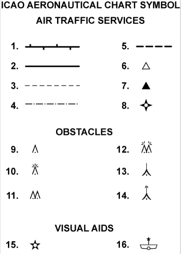
Which aeronautical chart symbol indicates a group of lighted obstacles?